What is an expressway kilometer post? And why both directions show the same number
A kilometer post (distance marker) shows the distance from the start of a route, and on Japanese expressways one stands beside the road every 100 m. Why both carriageways show the same number, how to write positions between posts, and how posts are used in reporting and road management.
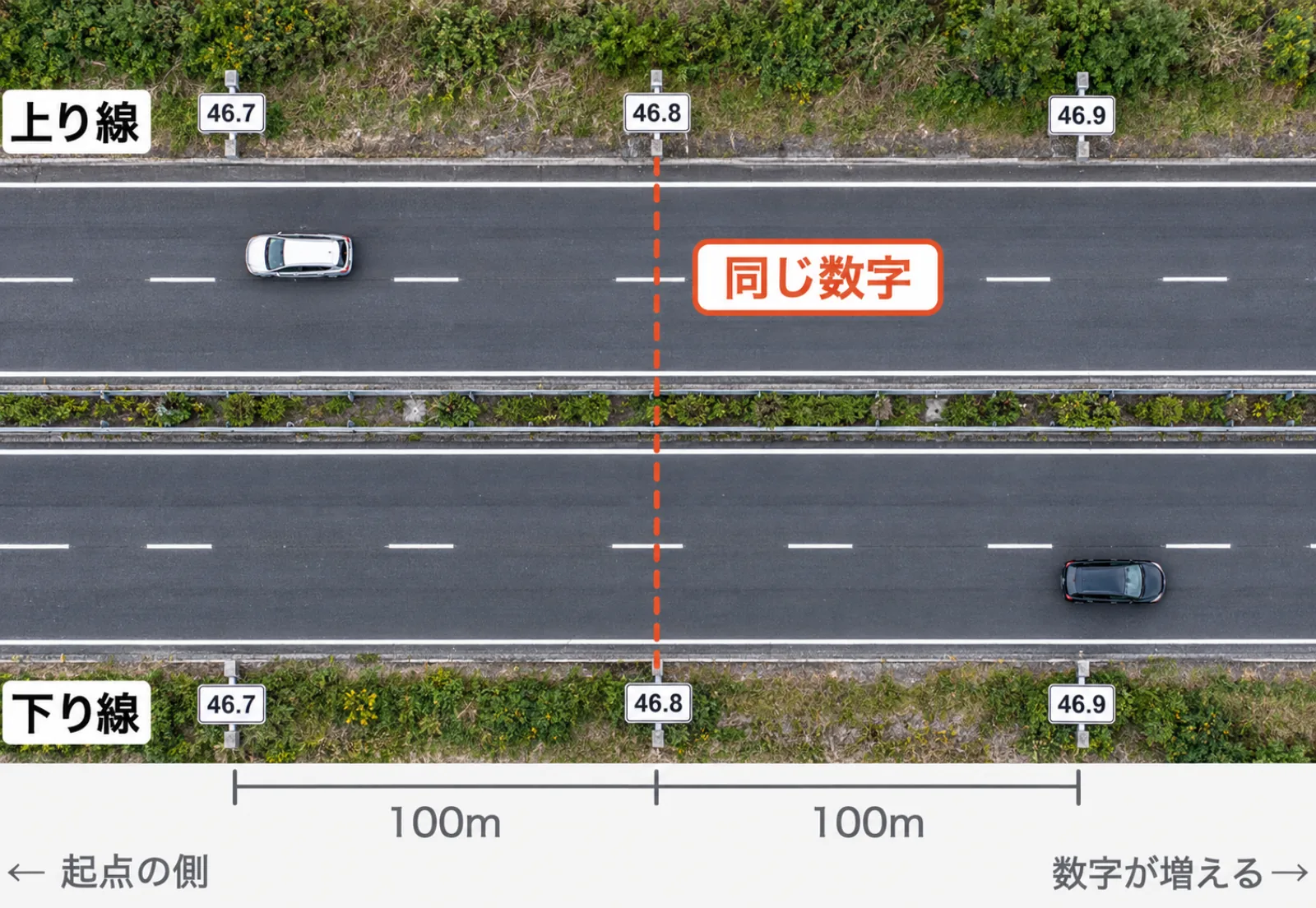
A kilometer post (distance marker) is a sign showing how many kilometres a spot is from the start of that road. On Japanese expressways one stands beside the road every 100 m; one reading "46.8" is 46.8 km from the start (Source: NEXCO Central). Each route has only one start point, so the same number stands at the same spot on both carriageways. When reporting an accident or breakdown, give the number of a nearby kilometer post along with the road name and your direction of travel.
Distance from where?
Each expressway has one set start point. The Kita-Kanto Expressway, for example, starts at Takasaki JCT, so a "46.8" kilometer post on it is 46.8 km from Takasaki JCT (Source: NEXCO East Drive Plaza).
The numbers have one decimal place, so they go up in steps of 0.1 km. Driving away from the start, the numbers rise; driving towards it, they fall. Whether they are rising or falling also tells you which way you are going.
Each route has its own start point, so the same "46.8" exists on other routes too. In records and notes, always pair it with the route name, as in "Kita-Kanto Expressway 46.8".
Why do both carriageways show the same number?
Because expressways don't have separate start points for each direction; each route has just one (NEXCO East Drive Plaza). Kilometer posts on both shoulders show the distance measured from the same start point (Fig. 1).
So the number alone doesn't tell you which carriageway someone means. The Road Emergency Dial (#9910) also asks callers to check the road name, direction of travel, kilometer post and nearby facilities so the spot can be identified (Source: MLIT). Give the direction and the number together, as in "heading towards X, around kilometer post 46.8".
Using kilometer posts in an accident or breakdown
NEXCO Central gives this order of steps when your car stops on an expressway (Source: NEXCO Central Drivers' Site).
- Don't walk around outside the car
- Warn following traffic with hazard lights, flares and a warning triangle
- Get everyone, passengers included, to safety behind the guardrail
- Once safe, report by calling 110, using an emergency phone, or calling the Road Emergency Dial (#9910)
The kilometer post number is used in step 4. Remember the number you saw just before stopping, or check a kilometer post visible from behind the guardrail after getting to safety. If you don't know the number, give the name of the last interchange or service or parking area you passed.
Roadside emergency phones are starting to disappear. Citing the spread of mobile phones, NEXCO East began withdrawing emergency phones, except in tunnels and rest areas, on some sections such as the E16 Yokohama-Yokosuka Road from May 11, 2026. In their place it points to #9910, free to call from a mobile phone anywhere, and its LINE reporting (Source: NEXCO East).
How do you write a spot between two kilometer posts?
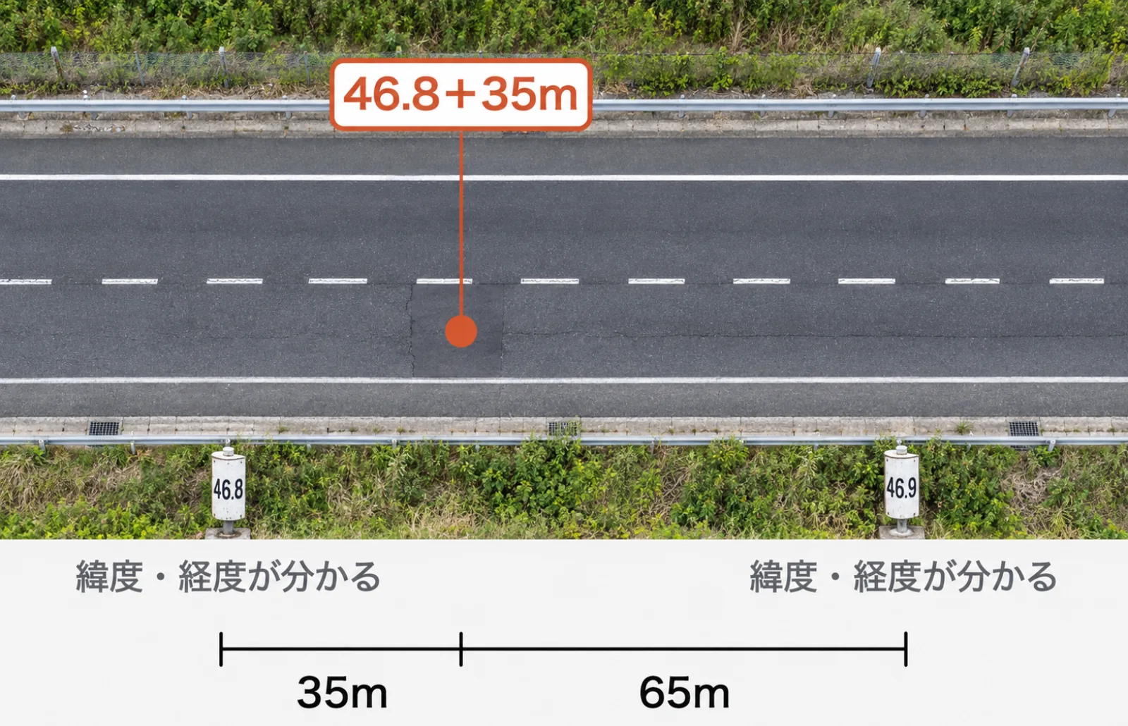
In road management, a position is written as the number of the nearest kilometer post behind it plus the distance travelled from there in metres. A spot 35 m past the 46.8 post is "46.8 + 35 m", or 46.835 km from the start (Fig. 2).
The form-filling manual for distance marker surveys published by MLIT's Chugoku Regional Development Bureau also records position in two fields, the 100 m marker (km) and the distance (m) (Source: MLIT Chugoku Regional Development Bureau). The same manual also records the length (m) to the next marker and which side of the road the marker stands on.
| Side | Code |
|---|---|
| Both carriageways | 0 |
| Up-line side | 1 |
| Down-line side | 2 |
| Centre of main line | 3 |
Written this way, records on the same route can be put in order, and the distance between them found, just by comparing numbers. It also works well for matching inspection records against repair records to check whether they refer to the same spot.
What does linking kilometer posts to coordinates make possible?
A position written as "X km + Y m" can't be placed on a map as it is, because maps and GIS (software that layers data on maps) take positions as latitude and longitude. If the coordinates of each kilometer post are known, the dot in Fig. 2 can be placed on the map as the spot 35 m on from 46.8, based on the positions of the posts on either side.
A table matching kilometer posts to coordinates lets you:
- Show "around kilometer post 46.8" in reports and inspection records as a point on a map
- Find the nearest kilometer post to coordinates recorded by a smartphone or similar, and put them in the form road records use
- Overlay data managed by coordinates, such as municipal boundaries, weather stations or other road facilities
The second helps connect records from people unfamiliar with kilometer posts to road management records. The first, conversely, is for when records arrive by kilometer post and you want to see the spot on a map.
FAQ
Q. Do ordinary roads have kilometer posts?
National roads have them too. MLIT's Saiki River and National Road Office describes distance markers as signs showing length for road management, "something like the road's address". Typically there is a triangular stone post every 1 km and a plate every 100 m (Source: MLIT Saiki River and National Road Office).
Q. Are the number signs on river embankments the same thing?
Yes, they are also distance markers. According to the same office, distance markers are used in river management as well, including on the Bansho River.
For road users: read next Who do you contact when you find a hole in the road? / National, prefectural or municipal road: how do you tell?
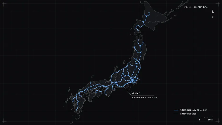
If you need kilometer post positions as data Infra Intelligence's Kilometer Post Data gives the latitude and longitude of expressway kilometer posts as a CSV every 100 m for each route. Positions on completed routes can be checked on the map, and a sample for the Shin-Tomei Expressway is free to download.
Last checked: October 13, 2026
References (in Japanese)
- NEXCO Central: What are the signs with numbers beside the road?
- NEXCO East Drive Plaza: What do the numbers on expressway shoulders mean?
- NEXCO Central Drivers' Site: If you have an accident or breakdown
- NEXCO East: Withdrawal of some expressway emergency phones, April 27, 2026
- MLIT: Road Emergency Dial (#9910)
- MLIT Chugoku Regional Development Bureau: Form-filling manual for distance marker surveys (E260)
- MLIT Kyushu Regional Development Bureau, Saiki River and National Road Office: What is a distance marker (kilometer post)?