National, prefectural or municipal road: how do you tell? And why some national roads are run by prefectures
A blue rice-ball-shaped sign means a national road; a hexagon means a prefectural road. If there is neither, it may be a municipal or private road. Why some national road sections are managed by prefectures, how to check on a map, and #9910 when you're not sure.
If you see a blue route number sign shaped like a rice ball that narrows at the bottom, it's a national road; a blue hexagon means a prefectural road. If neither appears at nearby intersections, it may be a municipal road or a private road. To be sure, check the municipality's map of certified routes. Even if you don't know who manages the road, you can report holes and other problems to the Road Emergency Dial (#9910).
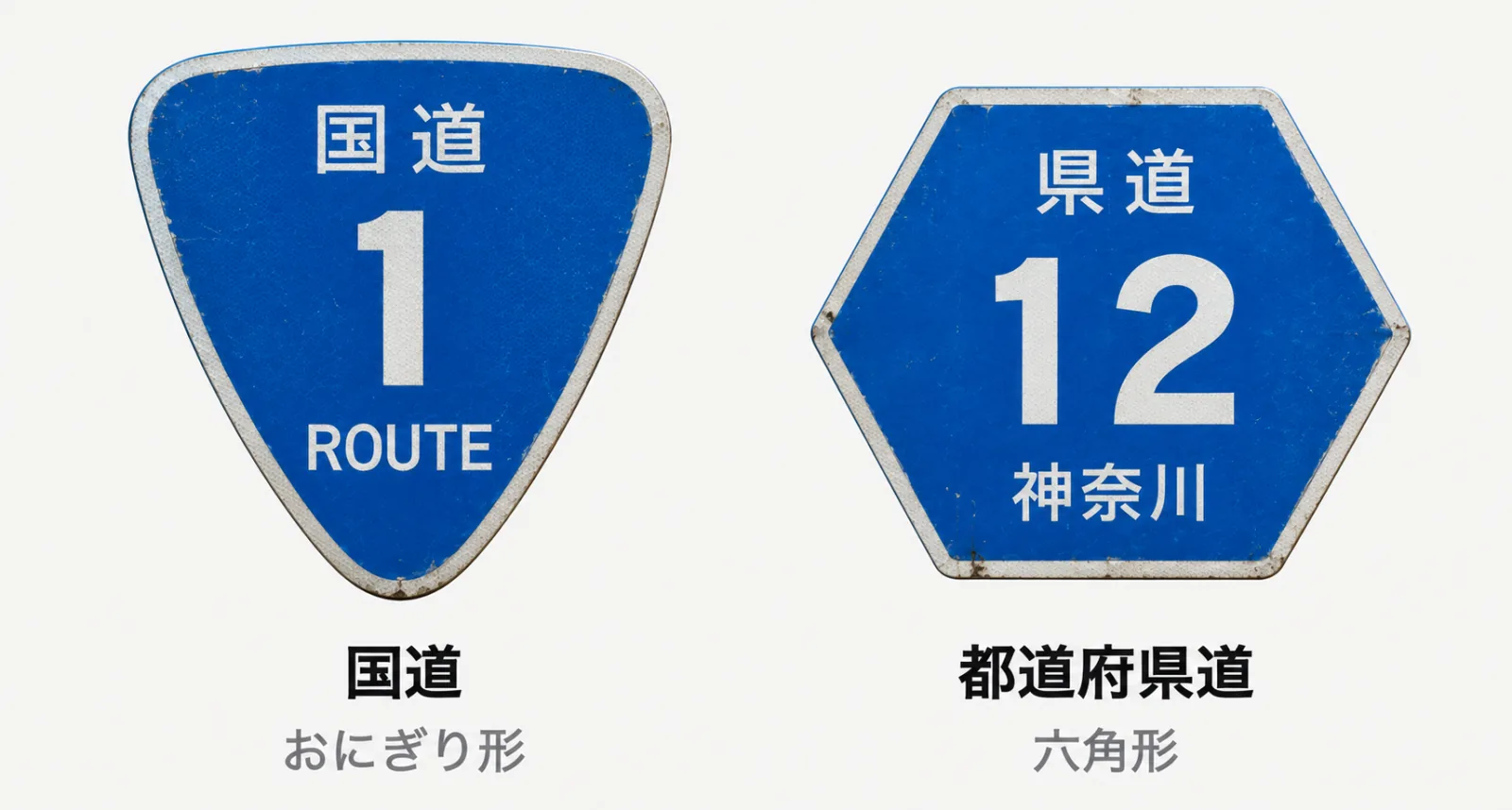
What to look for on the sign
Look at the shape of the sign showing the route number. National roads use a shape that narrows towards the bottom, with "ROUTE" written below. Prefectural roads use a hexagon with the prefecture's name below. Signs in white on green, such as "E1", are expressway numbers (Source: MLIT, List of Road Signs).
These signs are supposed to stand at major intersections on national and prefectural roads (Source: MLIT, Road Sign Installation Standards). So even on a national or prefectural road, you may not see one near where you are. There are no number signs for municipal roads.
Checking on a map
On maps from the Geospatial Information Authority of Japan (GSI), national and prefectural roads are shown in set colours, and national roads also carry their numbers (Source: GSI, Map symbols: national roads). Open the place in GSI Maps on the web and you can tell roughly whether it's a national or prefectural road. It won't tell you, though, whether the state or the prefecture manages that section.
Whether a road is a municipal road is checked on the route map the municipality publishes. It shows the routes certified as municipal roads and is often called a certified route map. Okayama City, for example, explains that you can check on the certified route map in the city's map system (Source: Okayama City).
For other municipalities, searching for the municipality's name with 認定路線網図 usually finds the right page. If the map isn't clear, the surest way is to ask to see the road register at the office, or to ask the roads department. Road managers cannot refuse a request to see the road register (Road Act Art. 28).
Who manages it?
Reports of holes and questions about damage to your car go to that road's manager. The manager is broadly decided by the type of road.
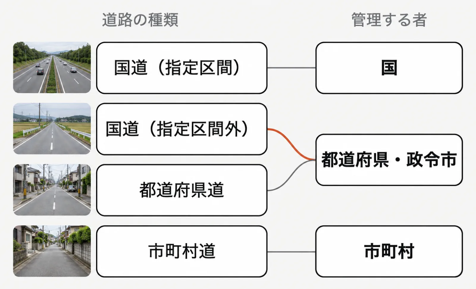
Even on national roads, the state handles upkeep and repairs only on the "designated sections" set by cabinet order. Other national roads are managed by the prefecture, just like prefectural roads, and within a designated city by that city. Municipal roads are managed by the municipality. In some cases, by agreement with the prefecture, a municipality manages a prefectural road (Road Act Arts. 13 and 15 to 17).
Even with the same route number, the manager changes by section. On National Route 180, for example, the designated sections are two: from Okayama City to Soja City, and from Yonago City to Matsue City (Source: Cabinet Order designating designated sections of general national roads). State-managed sections can sometimes be checked on the local national road office's website.
What if it's a private road?
A private road not certified by the municipality as a municipal road is not a road under the Road Act (Road Act Arts. 3 and 8). A private road is its owner's property and is maintained at the owner's responsibility (Source: Kodaira City). Some local governments, like Kodaira City, pay 90% of repair costs on private roads and carry out the work themselves.
Whether you may repair a hole in a private road yourself, and what help is available, is explained in Can you fill a hole in the road yourself?
If you're not sure, give the location to #9910
Even if you don't know the manager, you can phone the Road Emergency Dial (#9910). It's open 24 hours and calls are free (Source: MLIT). Through LINE you can report problems on expressways, national, prefectural and municipal roads. Private land such as private roads is not covered (Source: MLIT).
Checking the following before you report helps get the location across accurately.
- Road name (National Route X, Prefectural Road X, etc.)
- Direction of travel
- Kilometer post
- A nearby facility that serves as a landmark
A kilometer post (distance marker) shows roughly how many kilometres the spot is from the start of that route. Stop your car somewhere safe before checking signs or kilometer posts. LINE reports are handled when the manager can be identified from the location sent, so send the location accurately. If there has been an accident, contact the police (110).
FAQ
Q. What happens if I contact the city office by mistake?
Some local governments pass the information on to the right manager. Fukuoka City, for example, says that when its LINE reporting receives information about a national or prefectural road, it forwards it to the manager if the manager can be identified (Source: Fukuoka City).
Q. Where do I report a hole on an expressway?
The Road Emergency Dial (#9910) LINE reporting covers expressways too. When to use it versus the city office, and how to report, is explained in Who do you contact when you find a hole in the road?
For road users: read next What if a pothole gives you a flat tyre?
For road managers Infra Intelligence is developing MICHIKARTE, a service that lets people record damage they find on the roads they use every day with a smartphone and passes it on to the local governments and others who manage those roads. See the MICHIKARTE page.
Last checked: September 27, 2026
References (in Japanese)
- e-Gov Law Search: Road Act
- e-Gov Law Search: Cabinet Order designating designated sections of general national roads
- MLIT: List of Road Signs
- MLIT: Road Sign Installation Standards
- GSI: Map symbols: national roads
- GSI: Map symbols: prefectural roads
- GSI Maps
- Okayama City: How can I find out whether a road is a city road?
- Kodaira City: The city pays 90% of private road repair costs and does the work
- MLIT: Road Emergency Dial (#9910)
- MLIT: Road problems anywhere in Japan can now be reported via the LINE app (March 22, 2024)
- MLIT Saiki River and National Road Office: What is a distance marker (kilometer post)?
- Fukuoka City: Report problems with roads, parks, rivers and more via LINE