Free
Sample
Gotemba JCT to Toyota-Higashi JCT, in the same format as the paid data.
- Route
- Shin-Tomei Expressway (every 100 m)
- Formats
- CSV (kilometer post, latitude, longitude)
- Get it
- Download right here
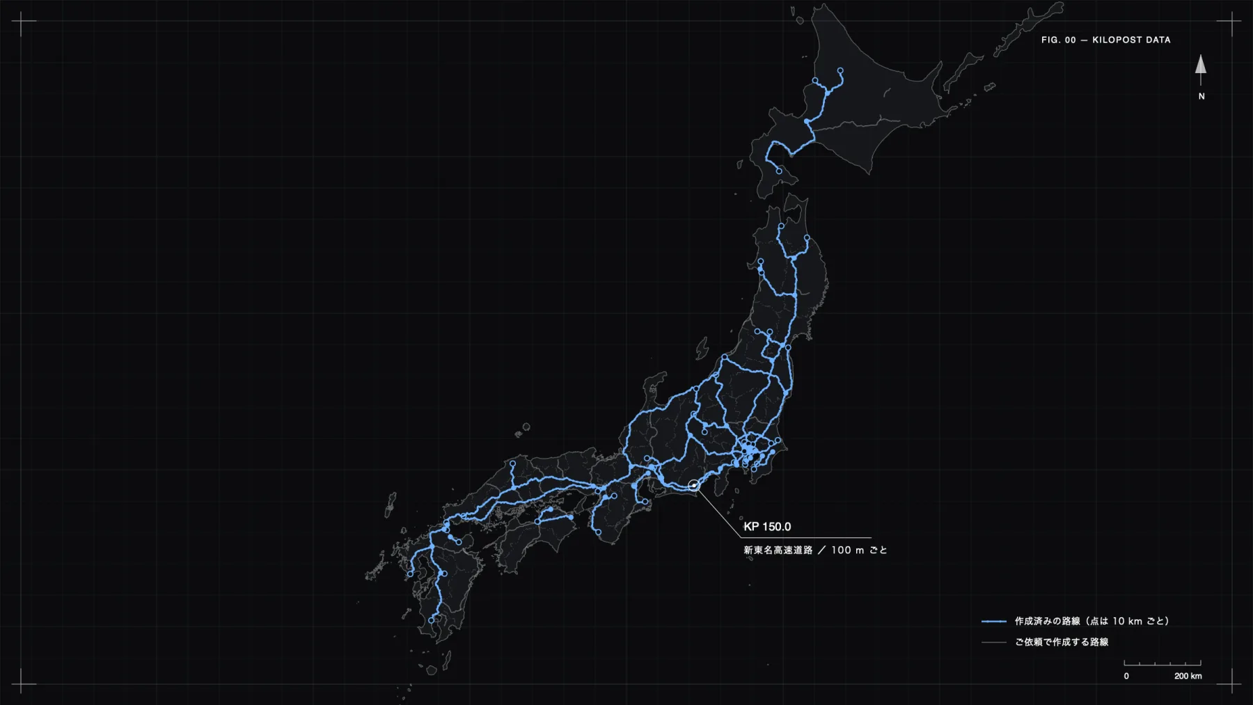
The kilometer posts (distance markers) along Japan's expressways, delivered as a list of latitude and longitude every 100 m. The Shin-Tomei Expressway sample is a free download; other routes are paid.
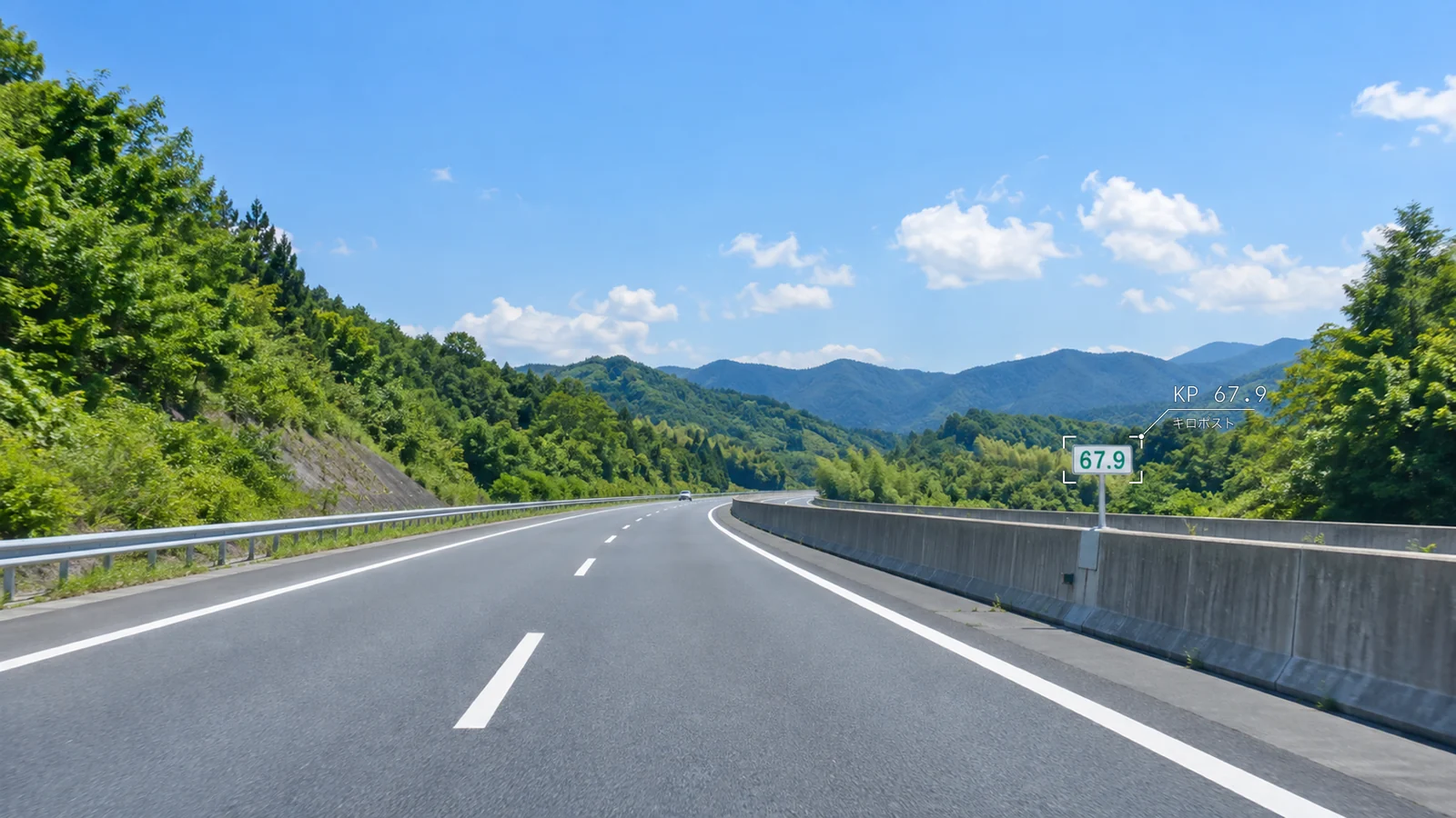
A post reading 67.9 stands 67.9 km from the start of that route.
They stand on the shoulder or median every 100 m (0.1 km). Posts at each whole kilometer have reversed colors so they stand out.
On expressways, with no intersections or traffic lights, accidents, roadworks and debris are located as near KP 67.9.
Spacing and colors are based on an interview with NEXCO Central Japan (Source: Norimono News, July 27, 2017, in Japanese)
One post, one row of data
Linking kilometer post values to map positions lets you handle locations in inspection records, dashcam footage and reports by either KP or latitude and longitude.
View on the mapThe latitude and longitude values come in the data you receive.
Route shapes and prefecture borders: processed from National Land Numerical Information (expressway time series and administrative area data)Background: GSI Tiles
Ready77 routes
Ready
Chuo Expressway
Sections being checked will be updated in the data once confirmed.
Request a quote for this routeReady
Kan-etsu Expressway
Sections being checked will be updated in the data once confirmed.
Request a quote for this routeReady
Nagano Expressway
Ready
Tomei Expressway
Sections being checked will be updated in the data once confirmed.
Request a quote for this routeReady
Meishin Expressway
Sections being checked will be updated in the data once confirmed.
Request a quote for this routeReady
Shin-Tomei Expressway
Sections being checked will be updated in the data once confirmed.
Request a quote for this routeReady
Tohoku Expressway
Sections being checked will be updated in the data once confirmed.
Request a quote for this routeReady
Sanyo Expressway
Sections being checked will be updated in the data once confirmed.
Request a quote for this routeReady
Chugoku Expressway
Sections being checked will be updated in the data once confirmed.
Request a quote for this routeReady
Kyushu Expressway
Sections being checked will be updated in the data once confirmed.
Request a quote for this routeReady
Hokuriku Expressway
Sections being checked will be updated in the data once confirmed.
Request a quote for this routeReady
Joban Expressway
Sections being checked will be updated in the data once confirmed.
Request a quote for this routeReady
Joshin-etsu Expressway
Ready
Do-O Expressway
Sections being checked will be updated in the data once confirmed.
Request a quote for this routeReady
Do-O Expressway
Ready
Higashi-Kanto Expressway
Ready
Kita-Kanto Expressway
Ready
Kita-Kanto Expressway
Sections being checked will be updated in the data once confirmed.
Request a quote for this routeReady
Ban-etsu Expressway
Sections being checked will be updated in the data once confirmed.
Request a quote for this routeReady
Tokai-Hokuriku Expressway
Sections being checked will be updated in the data once confirmed.
Request a quote for this routeReady
Nagasaki Expressway
Sections being checked will be updated in the data once confirmed.
Request a quote for this routeReady
Higashi-Meihan Expressway
Ready
Nishi-Meihan Expressway
Ready
Isewangan Expressway
Ready
Shin-Meishin Expressway
Sections being checked will be updated in the data once confirmed.
Request a quote for this routeReady
Shin-Meishin Expressway
Ready
Ise Expressway
Sections being checked will be updated in the data once confirmed.
Request a quote for this routeReady
Hanwa Expressway
Sections being checked will be updated in the data once confirmed.
Request a quote for this routeReady
Maizuru-Wakasa Expressway
Sections being checked will be updated in the data once confirmed.
Request a quote for this routeReady
Tottori Expressway
Sections being checked will be updated in the data once confirmed.
Request a quote for this routeReady
Matsue Expressway
Sections being checked will be updated in the data once confirmed.
Request a quote for this routeReady
Tokushima Expressway
Ready
Takamatsu Expressway
Sections being checked will be updated in the data once confirmed.
Request a quote for this routeReady
Takamatsu Expressway
Ready
Matsuyama Expressway
Sections being checked will be updated in the data once confirmed.
Request a quote for this routeReady
Kochi Expressway
Sections being checked will be updated in the data once confirmed.
Request a quote for this routeReady
Miyazaki Expressway
Sections being checked will be updated in the data once confirmed.
Request a quote for this routeReady
Higashi-Kyushu Expressway
Ready
Higashi-Kyushu Expressway
Ready
Higashi-Kyushu Expressway
Sections being checked will be updated in the data once confirmed.
Request a quote for this routeReady
Higashi-Kyushu Expressway
Ready
Kyushu-Chuo Expressway
Ready
Hachinohe Expressway
Sections being checked will be updated in the data once confirmed.
Request a quote for this routeReady
Akita Expressway
Ready
Akita Expressway
Ready
Kamaishi Expressway
Sections being checked will be updated in the data once confirmed.
Request a quote for this routeReady
Yamagata Expressway
Sections being checked will be updated in the data once confirmed.
Request a quote for this routeReady
Yamagata Expressway
Ready
Nihonkai-Tohoku Expressway
Sections being checked will be updated in the data once confirmed.
Request a quote for this routeReady
Nihonkai-Tohoku Expressway
Sections being checked will be updated in the data once confirmed.
Request a quote for this routeReady
Tohoku-Chuo Expressway
Sections being checked will be updated in the data once confirmed.
Request a quote for this routeReady
Doto Expressway
Sections being checked will be updated in the data once confirmed.
Request a quote for this routeReady
Fukagawa-Rumoi Expressway
Ready
Chubu-Odan Expressway
Sections being checked will be updated in the data once confirmed.
Request a quote for this routeReady
Chubu-Odan Expressway
Ready
Ken-O Expressway
Ready
Ken-O Expressway
Sections being checked will be updated in the data once confirmed.
Request a quote for this routeReady
Tokai-Kanjo Expressway
Sections being checked will be updated in the data once confirmed.
Request a quote for this routeReady
Kanmon Expressway
Ready
Shin-Tomei Expressway
Ready
Tateyama Expressway
Ready
Shuto Expressway Route 1 Haneda
Ready
Shuto Expressway Route 3 Shibuya
Ready
Shuto Expressway Route 4 Shinjuku
Ready
Shuto Expressway Route 5 Ikebukuro
Ready
Shuto Expressway Route 6 Mukojima
Ready
Shuto Expressway Route 6 Misato
Ready
Shuto Expressway Route 7 Komatsugawa
Ready
Shuto Expressway Route 9 Fukagawa
Ready
Shuto Expressway Central Circular Route
Sections being checked will be updated in the data once confirmed.
Request a quote for this routeReady
Shuto Expressway Saitama Omiya Route
Ready
Shuto Expressway Kawaguchi Route
Ready
Shuto Expressway Bayshore Route
Ready
Shuto Expressway K1 Yokohane
Ready
Shuto Expressway K3 Kariba
Ready
Shuto Expressway K6 Kawasaki
Ready
Shuto Expressway K7 Yokohama-Hokusen
In progress
Okinawa Expressway
This route is being made. For urgent requests, the quote will include price and delivery time.
Request a quote for this routeIn progress
Kinki Expressway
This route is being made. For urgent requests, the quote will include price and delivery time.
Request a quote for this routeIn progress
Okayama Expressway
This route is being made. For urgent requests, the quote will include price and delivery time.
Request a quote for this routeIn progress
Hiroshima Expressway
This route is being made. For urgent requests, the quote will include price and delivery time.
Request a quote for this routeIn progress
Nihonkai-Tohoku Expressway
This route is being made. For urgent requests, the quote will include price and delivery time.
Request a quote for this routeIn progress
Chubu-Odan Expressway
This route is being made. For urgent requests, the quote will include price and delivery time.
Request a quote for this routeIn progress
Shuto Expressway Inner Circular Route
This route is being made. For urgent requests, the quote will include price and delivery time.
Request a quote for this routeIn progress
Shuto Expressway Inner Circular Route
This route is being made. For urgent requests, the quote will include price and delivery time.
Request a quote for this routeIn progress
Shuto Expressway Inner Circular Route
This route is being made. For urgent requests, the quote will include price and delivery time.
Request a quote for this routeIn progress
Shuto Expressway Route 1 Ueno
This route is being made. For urgent requests, the quote will include price and delivery time.
Request a quote for this routeIn progress
Shuto Expressway Route 2 Meguro
This route is being made. For urgent requests, the quote will include price and delivery time.
Request a quote for this routeIn progress
Shuto Expressway Route 10 Harumi
This route is being made. For urgent requests, the quote will include price and delivery time.
Request a quote for this routeIn progress
Shuto Expressway Route 11 Daiba
This route is being made. For urgent requests, the quote will include price and delivery time.
Request a quote for this routeIn progress
Shuto Expressway K2 Mitsuzawa
This route is being made. For urgent requests, the quote will include price and delivery time.
Request a quote for this routeIn progress
Shuto Expressway K5 Daikoku
This route is being made. For urgent requests, the quote will include price and delivery time.
Request a quote for this routeOn request
Oita Expressway
This route is made on request. The quote will include price and delivery time.
Request a quote for this routeOn request
Kisei Expressway
This route is made on request. The quote will include price and delivery time.
Request a quote for this routeOn request
Kisei Expressway
This route is made on request. The quote will include price and delivery time.
Request a quote for this routeOn request
Yonago Expressway
This route is made on request. The quote will include price and delivery time.
Request a quote for this routeOn request
Onomichi Expressway
This route is made on request. The quote will include price and delivery time.
Request a quote for this routeOn request
Hamada Expressway
This route is made on request. The quote will include price and delivery time.
Request a quote for this routeOn request
Doto Expressway
This route is made on request. The quote will include price and delivery time.
Request a quote for this routeOn request
Hokkaido Odan Expressway (Abashiri Line)
This route is made on request. The quote will include price and delivery time.
Request a quote for this routeOn request
Tokai-Kanjo Expressway
This route is made on request. The quote will include price and delivery time.
Request a quote for this routeOn request
Tokai-Kanjo Expressway
This route is made on request. The quote will include price and delivery time.
Request a quote for this routeOn request
Shuto Expressway Yaesu Route
This route is made on request. The quote will include price and delivery time.
Request a quote for this routeOn request
Shuto Expressway Saitama Shintoshin Route
This route is made on request. The quote will include price and delivery time.
Request a quote for this routeA free CSV in the same format as the paid data, covering the Shin-Tomei Expressway from Gotemba JCT to Toyota-Higashi JCT every 100 m.
| KP | Latitude | Longitude |
|---|---|---|
| 52.8 | 35.267101 | 138.913776 |
| 52.9 | 35.266292 | 138.913309 |
| 53.0 | 35.265483 | 138.912843 |
| 53.1 | 35.264674 | 138.912377 |
| 53.2 | 35.263857 | 138.911935 |
Inbound and outbound lanes are not separated. Column notes and sources (README)
The number on each post, one row every 0.1 km (100 m).
Each post's position as a point on the main carriageway's center line, in WGS84 latitude and longitude.
Each route is one CSV with three columns, ready to open in a spreadsheet or mapping software.
Free
Gotemba JCT to Toyota-Higashi JCT, in the same format as the paid data.
Per route
¥10,000 per 100 km
A 300 km route costs ¥30,000.
Bundle
¥100,000
Good value when you need several long routes.
All
¥600,000
Every route finished at the time of your order.
Use the form to say which routes or plan you want and how you will use them.
You get the price for your routes and payment details. For routes still in progress, feasibility and delivery time are confirmed too.
If the quote works for you, make the payment.
Once payment is confirmed, you receive one CSV per route.
Q.01What can I use the sample for?
It is for checking the format and positions before you buy. If you use it, include the attribution given in the README.
Q.02Which routes can I buy?
Routes marked Ready on the map are available now. Other expressways can be made on request. Some sections may not be possible; you will be told when you ask.
Q.03How is the price set?
By route length: ¥10,000 per 100 km. There are also prices for a five-route bundle and for all routes.
Q.04Can I see latitude and longitude on the map?
No. The map shows positions every 100 m, but not the values.
Q.05How accurate are the positions?
You can check positions on this page's map before buying. Accuracy figures will be published once they are ready.
Q.06Are inbound and outbound lanes separate?
Not in the sample. Where the carriageways run apart, KP values can differ, so mention when ordering whether you need them separated.
Q.07How do I pay?
Payment details come with the quote.
Q.08Do you cover ordinary roads?
Expressways only, for now.
Q.09What format is the data?
One CSV per route with three columns: kilometer post, latitude and longitude. Ask if you need another format.
Whether it is a MICHIKARTE trial or an AI app, your plans do not need to be final. Describe the photos or video you have and what you are struggling with, and you will get an email reply on what can and cannot be done. The contact form is in Japanese, but you are welcome to write in English.